We are building a safer, stronger future at Cressbrook Dam through Queensland's largest local government-led dam safety project.
The safety improvements to Cressbrook Dam, including widening the spillway and raising the crest, will ensure the dam can safely pass larger volumes of water in a major flood event. These upgrades are essential to meet modern safety and engineering standards.
The Cressbrook Dam Safety Improvement Project (CDSIP) is mandated by the Queensland Government Department of Local Government, Water and Volunteers. Under the guidelines, as a responsible dam owner, we must achieve an 'As Low as Reasonably Practicable' (ALARP) risk position to increase flood resilience and protect downstream communities.
If you're curious about the CDSIP site, view our interactive site map and discover the true size and scale of the project.
To stay up to date and learn more about the project, subscribe to our monthly community update.
Subscribe now
This project is being delivered by Toowoomba Regional Council, SMEC Australia, and Seymour Whyte Constructions.
The CDSIP is currently in the design phase. It's a complex project that carries considerable risk. Our goal is to do the work once and do it properly. The way we make Cressbrook Dam safer matters, as this project is about improving water security, through disaster resilience, for the Toowoomba Region community and to protect life downstream. It's too dam important to get wrong!
As part of the design phase, improvement works will be undertaken on three Somerset Regional Council (SRC) roads. The improvements will ensure Kipper Creek Road, Cressbrook Creek Road and Wivenhoe Pipeline Access Road can safely accommodate heavy vehicle movements ahead of major CDSIP construction.
We have welcomed the State Government's $54 million funding commitment towards the CDSIP.
We continue our advocacy efforts with the Federal Government.
Improving Cressbrook Dam:
- protects and maintains our Region’s water for businesses and residents
- improves dam safety for downstream communities during major flooding events
- provides better dam monitoring and data inputs to assist us to make decisions during weather events
- complies with state regulation and best practice objectives
- provides opportunities for local growth.
63 per cent of our water storage capacity is at Cressbrook Dam. If it were to fail, not only would it be catastrophic for downstream communities, but it would threaten one of our primary water sources; water our community relies on every day. Safeguarding that supply is essential. While we’re not increasing our water storage capacity, this is about protecting our existing water infrastructure.
Before improvements
After improvements
Purpose of the project
We are building a safer, stronger future by protecting life and improving water security at Cressbrook Dam. This project has been mandated by the Queensland Government, but Cressbrook Dam belongs to the Toowoomba Region; it's community owned infrastructure which carries shared responsibility. The CDSIP will enhance flood resilience, making the dam safer and decreasing the likelihood of failure. It will also protect downstream communities in the Somerset Regional Council area. Industry standards have evolved and so has the level of risk we can responsibly accept as the dam owner. We are committed to upholding only well recognised, best practice standards, nothing less.
ALARP requirements
Cressbrook Dam is a referable dam. A referable dam is defined as a dam that poses a potential risk to downstream populations if it were to fail and dam safety standards exist to protect downstream communities. We are applying a risk-based approach to design the safety improvements to ‘As Low as Reasonably Practicable’ (ALARP) to meet the requirements set out under the Water Supply (Safety and Reliability) Act 2008.
We are carefully assessing potential risks, including dam failure and flood impacts and are evaluating risk reduction measures to determine the most effective solutions.
Safety measures are also balanced against factors such as cost, practicality, and environmental impact to find the best solution to ensure safety, efficiency and sustainability.
Construction phase
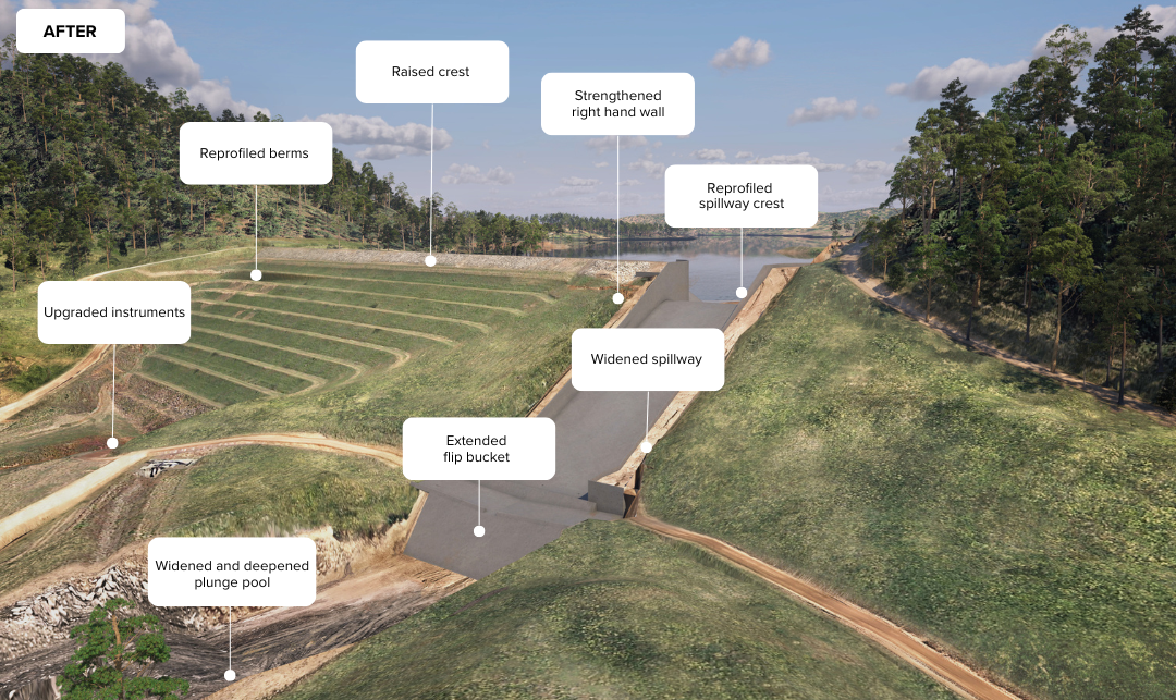
Construction work will include:
- widening the spillway to the left bank
- raising the dam crest
- re-profiling berms
- strengthening the right-hand wall
- upgrading dam instruments
- widening and deepening the plunge pool
- re-profiling the spillway crest
- extending the spillway flip bucket.
Other works will include establishing site facilities, preparing local access roads and creek crossings which will be used by the team during construction activities, and restoring areas affected by construction.
Construction timeframe
CDSIP early construction work is underway, with main construction to commence in mid-2026.
Construction impacts
The team will be working Mondays to Saturdays, between 6am to 6pm.
Affected residents will be notified before the start of construction and if any work needs to be conducted outside of these hours.
The community may experience some temporary impacts, including dust, lighting and noise from machinery or vehicles and increased traffic or changed traffic conditions on local roads.
Where possible, the team will work to minimise impacts and will share information about the progress of the project.
Full security measures will be in place on site, including CCTV cameras.
Road impacts
The following Toowoomba Region roads are anticipated to be used by the project to access Cressbrook Dam (Lake Cressbrook):
- Cressbrook Recreation Road
- Esk-Hampton Road
- Mount Jockey Road
- New England Highway
- Pechey-Forestry Road
- Perseverance Dam Road
- Sebastapool Road (enabling works only).
The project team will monitor the condition of these local roads.
The following Somerset Regional roads may be used by the project to bring equipment and materials to the dam:
- Brennan Road
- Cressbrook Creek Road
- Esk-Crows Nest Road
- Gatton-Esk Road
- Kipper Creek Road
- Toogoolawah-Biarra Road
- Wivenhoe pipeline route.
Local business opportunities
The project team have placed high priority on maximising the local spend within the Toowoomba Region to support our community.
We encourage local businesses interested in supplying to the project to register an expression of interest through the project's ICN Gateway webpage. For all other procurement or labour hire enquiries, please email cressbrooksafetyimprovement@tr.qld.gov.au or call 131 872.
Cressbrook Dam facts
- Cressbrook Dam is located about 40 kilometres north-east of Toowoomba’s CBD.
- 63 per cent of the Toowoomba Region’s water storage capacity is at Cressbrook Dam.
- Cressbrook Dam has a storage capacity of 81,842 ML, that’s equivalent to approximately 71,000 outdoor Milne Bay pools full of water.
- Designed by Farr Evrat & Associates in the 1970s – 1980, Cressbrook Dam was constructed from 1981 – 1983.
- The dam is a central core zoned earth-fill embankment with a concrete-lined spillway on the left abutment.
- Cressbrook Dam first reached full supply level in May 1989.
- The Wivenhoe Dam pipeline is used when Cressbrook Dam’s useable capacity falls below 40 per cent.
- Cressbrook Dam is classified as a referable dam. A referable dam is a dam whose failure would put two or more people at risk.
- Cressbrook Dam is the first of 13 referable dams in Queensland to undertake a safety improvement project.
- Cressbrook Dam currently has the equal fifth highest wall in Queensland; its dam wall is the same height as Wivenhoe Dam at 59 metres above natural surface level.
- The only Queensland dams with higher walls than Cressbrook are Split-Yard Creek, Boondooma, Glenlyon and Hinze Dams.
- The dam has a total catchment area of 320km2 (including Perseverance Dam).
- Current width of the spillway is 20 metres.
- The length of the dam wall is approximately 370 metres.
- Cressbrook Dam is 5km as the crow flies downstream of Perseverance Dam, but 8km following the course of Perseverance / Cressbrook Creek.
- Wivenhoe Dam is 25.5km as the crow flies downstream of Cressbrook Dam but 49km following the course of Cressbrook Creek / Brisbane River.
Current dam level
The Cressbrook Dam level needs to be at, or below 70 per cent for specific activities during construction. Unfortunately, we can't control the weather; the more rainfall the region receives the longer reduction of the dam level will take.
View the individual dam levels & daily use figures.